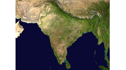
Any piece of land that has three sides of water and one side of land is considered a peninsula. Having the Indian Ocean to the south, an Arabian Sea to the west, as well as Bay of Bengal to the east gives India the geographical characteristics of a peninsula.
The following are the primary physiographic regions of India:
- The Peninsular Plateau
- The Indian Desert
- The Himalayan Mountains
- The Coastal Plains
- The Islands
- The Northern Plains
Peninsular Plateau
- It is one of the oldest landmasses on Earth’s surface.
- It is among the most stable landmasses, while the Himalayas are a volatile region.
- It is characterized by shallow, large valleys and gently rolling hills.
- It was created when Gondwana broke off and drifted.
- Metamorphic & igneous rock types can both be found on the Peninsular Plateau.
- The Aravalli hills stretch through Gujarat to Delhi along the western to northwest borders of the Peninsular flat.
- A significant part of Peninsular Plateau is a region of black dirt called the Deccan Trap.
- It is flanked by the coasts that extend perpendicular to the Arabian Sea to the west and the Bay of Bengal to the east.
2 broad divisions of peninsular plateau
Central Highlands and Deccan Plateau
Central Highlands
- The Central Highlands continue eastward into the territories known as Baghelkhand & Bundelkhand. Chotanagpur Plateau is the next extension that goes further eastward.
- The primary region that encompasses the Malwa plateau and can be found to the north of this Narmada River is known as the Central Highlands.
- These Central Highlands are stretched thinly across the eastern region.
- Widespread in the western region are the Central Highlands.
- The Chambal, Sindh, Betwa, Ken rivers are the ones that run through this region from southwest to northeast. The flow direction of these rivers is counterclockwise.
Deccan Plateau
- The Deccan Plateau is indeed a triangular piece of land that may be found on Narmada River’s south.
- The Mahadev Hills, the Kaimur Hills, and the Maikal Range are the easternmost Deccan Plateau expansions.
- The Satpura range runs parallel to the northern edge of Deccan plateau.
- In general, the Deccan Plateau rises to the west and gently tapers to the east.
- Chotanagpur Plateau & Deccan Plateau is physically divided by a geological fault.
- Meghalaya, Karbi-anglong plateau and North Cachar Hills are the examples of Deccan Plateau extension in its Northeast
This Peninsular plateau has been through several stages of upliftment and submergence, which have been accompanied with crustal faulting and fractures throughout geologic time. Because of these geographical changes, the topography of Peninsular plateau now possesses components that contribute to its richness.
Parkash Singh is a PGT Teacher in Kendriya Vidyalaya Rohini, New Delhi. Parkash completed his starting education from Bihar Board and graduated from Babasaheb Bhimrao Ambedkar Bihar University. He regularly writes educational and informative articles at IndiasStuffs.com
Page Contents


